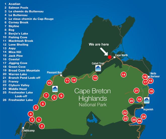
Cape Breton Highlands National Park's hiking trails range from easy strolls to challenging climbs with panoramic views of canyons, highlands and seacoasts. The trails provide a chance to intimately explore the complex habitat of northern Cape Breton Island. Nature doesn't end at the park's boundaries. Many surrounding areas boast equally breathtaking trails.
All these trails are right on our cottages door step.

The following is a list of Cape Breton Highlands National Park's hiking trails. Distances are round-trip with average walking times. Click on the trail name for more detailed information.
The trails have been rated for difficulty with the internationally recognized symbols:
|
|
Easy | Family-friendly trails that are suitable for all visitors. | ||
|
|
Moderate | Medium-length trails with moderate elevation gain and some short, steep sections. Suitable for most visitors. | ||
|
|
Difficult |
|
| Trail | Difficulty | Distance | Time | Elevation | |
| 1 | Acadian (loop) |
|
8.4 km | 3 - 4 hours | 20 - 365 m |
| 2 | Salmon Pools |
|
7.8 km | 3 - 4 hours | 15 - 110 m |
| 3 | Le Chemin du Buttereau |
|
4.6 km | 1.5 hours | 25 - 65 m |
| 4 | Le Buttereau (loop) |
|
1.6 km | 30 - 45 minutes | 0 - 55 m |
| 5 | Le vieux chemin du Cap-Rouge |
|
9 km | 2.5 - 3.5 hours | 40 - 110 m |
| 6 | Corney Brook |
|
6.5 km | 2 hours | 30 - 170 m |
| 7 | Skyline |
|
7 km or 8.7 km (loop) |
2 - 3 hours | 290 - 405 m |
| 8 | Bog (loop) |
|
0.5 km | 15 minutes | 410 m |
| 9 | Benjie's Lake |
|
3 km | 1 - 1.5 hours | 400 m |
| 10 | Fishing Cove |
|
12 km | 5 - 6 hours | 0 - 355 m |
| 11 | MacIntosh Brook |
|
1.7 km | 30 - 45 minutes | 30 - 65 m |
| 12 | Lone Shieling (loop) |
|
0.6 km | 15 minutes | 70 m |
| 13 | Aspy |
|
9.6 km | 3 - 4 hours | 60 - 450 m |
| 14 | Mica Hill |
|
7.9 km | 3 - 3.5 hours | 260 - 410 m |
| 15 | Jack Pine (loop) |
|
2.3 km | 1 hour | 0 - 50 m |
| 16 | Coastal |
|
11.3 km | 3 - 4 hours | 0 - 45 m |
| 17 | Jigging Cove (loop) |
|
2.4 km | 40 - 50 minutes | 50 - 65 m |
| 18 | Green Cove |
|
0.2 km | 10 minutes | 10 m |
| 19 | Broad Cove Mountain |
|
2.3 km | 1 hour | 35 - 180 m |
| 20 | Warren Lake (loop) |
|
4.7 km | 1.5 hours | 15 m |
| 21 | Branch Pond Look-off |
|
8.4 km | 2 - 3 hours | 100 - 305 m |
| 22 | Franey (loop) |
|
7.4 km | 2 - 3 hours | 95 - 430 m |
| 23 | Clyburn Valley |
|
8.5 km | 2 - 3 hours | 5 - 50 m |
| 24 | Middle Head |
|
3.8 km | 1.5 hours | 0 - 45 m |
| 25 | Freshwater Lake Look-off |
|
0.3 km | 10 minutes | 10 - 45 m |
| 26 | Freshwater Lake |
|
1.7 km | 30 - 40 minutes | 0 - 15 m |
For those hikers that enjoy less populated trails off the beaten path; these are some of their favorites. These trails are not part of the national park circuit but are well worth it if you enjoy moderate to challenging remote hiking with some good grade ascents and descents and spectacular views. These trails are not recommended for beginner hikers or young children. If you click the trail name you will get trail head coordinates plus other trail details. Note: many of these trails do not have cell service. These areas are the home to bears, coyotes, and moose so hike prepared
| Trail | Distance | Time | Elevation | |
| 1 | Sugar Loaf | 3.2 km | 1.5 hours | 350 m |
| 2 | Blueberry Hill (Close to Cheticamp) | 6.6 km | 2-3 hours | 440 m |
| 3 | Mountain Trail (Meat Cove) | 5.22 km | 2 hours 10 min | 277 m |
| 4 | Roberts Mountain (Pleasant Bay) | 3.73 km | 2 hrs 10 minutes | 328 m |
| 5 | Pollets Cove (Pleasant Bay) | 13.2 km | 10 hours | 830 m |
| 6 | Kauzmann Trail | 3.7 km | 2 hours | 106 m |
| 7 | Money Point Trail | 13.74 km | 5hrs 30 min | 750 m |
| 8 | Tenerife MountainTrail | 3.7 km | 1 hour | 298 m |